- HOME
- Wow! Cool Laboratory [Researcher Introduction]
- Tomohito Yamada
Wow! Cool Laboratory [Researcher Introduction]
Division of Field Engineering for the Environment,
Research Group of Hydraulic and Aquatic Environment Engineering,
Laboratory of River and Watershed Engineering
Field of research: hydro-meteorology, hydraulics, water resource engineering, geophysical fluid dynamics
Research themes: global water cycle, rainfall-runoff process, land and atmosphere interaction, rainfall/snowfall processes, predictability
E-mail: tomohito[a]eng.hokudai.ac.jp
Clarification of the global water cycle mechanism to contribute to environmental policies and disaster mitigation
Water resource issues are gaining global attention
Water is essential for life. It is said that 1.4 billion km3 of water exists on Earth. However, fresh water, which humans can actually use, constitutes only 0.8% of all water, and approximately seven billion people share these limited water resources. In some countries overseas, conflicts over water are at a crisis point and could become the cause of international incidents. The 21st century is called the “age of water.” The River and Watershed Engineering Laboratory, which Associate Professor Tomohito Yamada belongs to, is engaged in research to clarify the mechanism of the global water cycle and the development of theories and technologies that would help with water resource prediction and disaster mitigation.
“Water circulates among the atmosphere, oceans and land on a daily basis through the processes of precipitation and evapotranspiration (photo 1). However, it is difficult to obtain an accurate view of the water cycle on a global scale. In developing counties and unsafe regions, for example, it is difficult even to install rain gauges and collect data from them. So, we are advancing research aimed at clarifying the mechanism of the water cycle by obtaining accurate local data, measuring rainfall distribution based on information from satellites, and utilizing a numerical model referred to as a global climate model.”
The clarification of the global water cycle mechanism is an important theme deeply connected to global warming and other climate changes as well as disasters including typhoons, hurricanes and droughts. Research by Associate Professor Yamada and his team was adopted as part of the Research Program on Climate Change Adaptation by the Ministry of Education, Culture, Sports, Science and Technology in FY 2010, and has been utilized in national-level measures for disaster mitigation and the environment, for example, as a guide for plans for adapting to the impact of global warming.
Soil moisture supporting the water cycle in midcontinent regions
Considering the impact of human activities on the environment
Clouds that bring rain are made of water vapor in the atmosphere. In Japan, which is surrounded by sea, most water vapor is brought from the sea. In the water cycle in midcontinent regions, however, water falls on the land as rain and then evaporates to become clouds again. Associate Professor Yamada has focused on this phenomenon and is working on measuring soil moisture content, which indicates the wettability of the land surface, and research on evapotranspiration.
“Western Sahel in the African continent is prone to hurricanes. Our study has revealed that the amount of rainfall during summer in this region depends on soil wettability. Then, on the assumption that it might be possible to predict rainfall by monitoring how wet the soil surface is, we used atmospheric data and soil moisture data to predict the weather. As a result, we have substantially improved prediction accuracy.”
The target areas include Middle America, Africa, India and the Yellow River basin in China. These are densely populated areas with developed industries, where a great amount of water from rivers and under the ground is used for agricultural and industrial purposes (note 1).
“In recent years, there has been concern about a rise in sea level, and water expansion with rising temperatures and melting ice in the North and South Poles have been cited as major causes. Another cause may be the fact that humans use water from rivers, lakes and under the ground for agricultural and industrial purposes. A paper dealing with this matter (Associate Professor Yamada is a coauthor) was published in Nature Geoscience, and had a tremendous impact on researchers in the field.”
Associate Professor Yamada insists that in order to increase the accuracy of rainfall prediction in such regions, it is necessary not only to learn about the soil but also to consider the impact of human activities on the global-scale water cycle. In the laboratory, a numerical model using a global climate model is used to calculate the movement of water, including water distribution by humans, indicating the possibility of high-accuracy prediction. The research results are attracting attention from NASA and other research institutes around the world.
Improved accuracy for predicting a localized, intensive downpour
Utilizing research results for disaster mitigation policies
Over the last several years, localized downpours have wreaked enormous damage on Hokkaido. Associate Professor Yamada is also working on research to instantly predict sudden flood damage and help with disaster mitigation.
“Hiroshima Prefecture and Hokkaido were ravaged by torrential rains in 2014, and the levees of the Kinugawa River in Ibaraki Prefecture were washed out in 2015. These were attributed to rain clouds referred to as line-shaped rainbands that cause a large downpour of rain in a small area over several hours (note 2). Such rain clouds have often caused flood damage in Honshu (Japan’s main island), and the frequency of their occurrence has recently increased in Hokkaido. We have analyzed meteorological data over the past 21 years to clarify the mechanism of occurrence and the causes of the increase in frequency of occurrence in Hokkaido.”
Associate Professor Yamada participated in the team to investigate the flood damage of the Kinugawa River, and estimated the distribution of winds in clouds from radar data. He reproduced the movement of the line-shaped rainband over the Kinugawa River based on the data, and used the movement as an initial condition for weather prediction to improve the accuracy of predicting line-shaped rainbands.
“Scientific elucidation is not the only thing that matters. It is also important to utilize the findings for disaster mitigation and to protect the environment and lives. It is an effort to apply the findings from research to actual disaster mitigation measures and utilize them for local residents’ evacuation projects. We are currently studying plans in consultation with the authorities.”
| Note 1. | The Ogallala Aquifer beneath the breadbasket of the United States The Ogallala Aquifer beneath the breadbasket in the central southern region of the United States is fossil water stored in the glacial age. A great amount of the water is used for agricultural purposes, and in recent years, a lowering of the groundwater level has been a problem. Since agricultural crops produced in this region are exported to Japan, the water resource problem in the United States is deeply connected to Japan’s food situation. 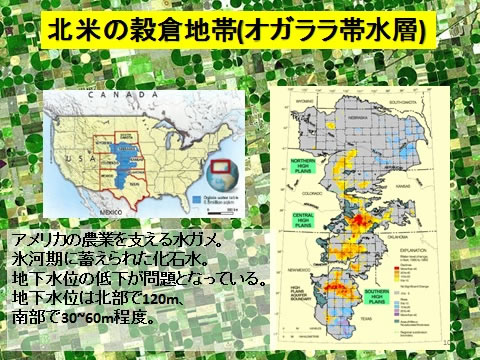
|
|---|---|
| Note 2. | Line-shaped rainband that caused the flooding of the Kinugawa River Data on the rainfall for 24 hours from September 9 to 10 in 2015. This shows a line-shaped rainband with a carrot-like shape. The area with the largest amount of rainfall saw 500 to 600 mm of rainfall in 24 hours. 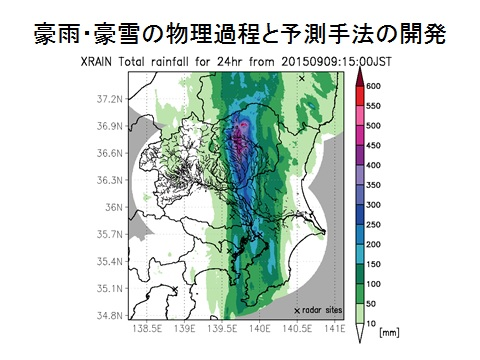
|
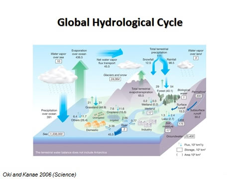
Photo 1. Global Hydrological Cycle
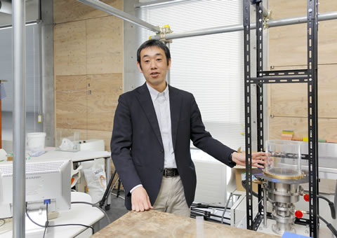
Photo 2. Indoor experiment
In the laboratory, a rotating water tank experimental device has been made to conduct comparative experiments with the real atmosphere. The cold/hot heat source installed on the bottom has enabled the removal of a wall that served as a cold/hot heat source, making it possible to observe meander amplitude and breaking waves.